History of GIS Development
USA
The National Mapping Division (NMD) of the U.S. Geological Survey (USGS) under U.S. Department of the Interior (US DoI) is the competent authority of the US geospatial information industry. The major mission of the NMD is: unitary collection of mapping data, management and distribution of earth science information, and geographic research and application (Ministry of the Interior, 2007:197).
In 1990, the US Office of Management and Budget (US OMB) established the Federal Geographical Data Committee (FGDC) with executive order Circular A-16. The FGDC is committed to establishing standards for the collection, registration, and interchange of geographical data to circulate and disseminate geographical data distributed across the government and society over the internet to achieve the goal of data sharing and integration (Ministry of the Interior, 2004:271; Ministry of the Interior, 2007:197). To effectively discuss concrete issues in detail regarding geospatial information, the FGDC has established committees, subcommittees, and working groups on various related topics and work items. The organizational chart of the FGDC is diagrammed below:
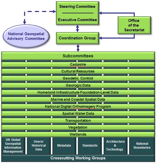
Overview of the structure of the various components of the FGDC
Under this framework, the Geo-Enabled Business under Geospatial Line of Business Work Groups and spatial information commercialization are extremely important. In addition, the Geospatial Enterprise Architecture, an active FGDC working group, is closely related to industrial development. The convening unit is USGS.
The US National Geospatial Information System (USNGIS) is constructed under the National Spatial Data Infrastructure (NSDI). NSDI participants included the US federal government, state government, local governments, and private enterprises. In data construction, management and circulation, USGS collectively produces all digital maps and provides them for relevant units free of charge on a reciprocal basis based on the USGS data provision regulations. These units then build application systems with such maps based on their duty. These maps are also provided for general users at their basic service charge (Ministry of the Interior, 2007:197).
The USNGIS is operated by government agencies, private enterprises, and academic and research institutions. The division of labor among them is: government departments establish information policy directions, create an environment for free circulation with complete security protection of information, and participate in the formation of international data standard organizations and the establishment of relevant specifications. Private enterprises and academic/research institutions guide the direction of technology specifications, such as data formats, while development software applications and software technologies (Ministry of the Interior, 2004: 271-272).
United Kingdom
The United Kingdom is formed by four political entities: England, Wales, Scotland, and Northern Ireland. The EU announced the Directive 2007/2/EC: Infrastructure for Spatial Information in the European Community (INSPIRE) in February 2007. To align with the EU’s geospatial information construction, the Local Government Association (LGA) of the UK proposed the “Geographic Information Strategy Recommendations” in 2007 to improve UK’s GI environment. On October 21, 2009, the Geospatial Information Policy (GI Policy) was amended. Currently, the UK implements geospatial information construction based on two main strategies: (1) INSPIRE and (2) the UK Location Strategy. Due to UK’s special political entity, the Location Strategy is exceptional important to eliminate policy obstacles and complicated administration permissions, and limitations on geospatial information sharing to enhance the function of geospatial information. On December 31, 2009, England, Wales, Scotland, and Northern Ireland made legislation to align with the INSPIRE directive, each administrative unit proposed individual GI strategies and organized relevant committee meetings, technology forums, and stakeholder forums. As the government organization and operation of each administration unit differ, GIS development is also different. One thing in common is that all of them consider the GIS as an emerging technology where existing spatial data processing is introduced, though without much aggressive push.
In the past, the UK promoted the National Geospatial Data Framework (NGDF). It was initiated by the Association for Geographic Information (AGI) in 1995, formed by the public and private sectors, and chaired by the head of Product Management, Ordnance Survey. The AGI founded in 1989 is an organization co-participated by the industry, the government, academics, and research institutions. It combines and shares the opinion and view of different sectors and promote exchange among them to expand commercial value, this making it exceptionally important. In 1996 the AGI assigned some important missions to the NGDF for implementation. Due to the conceptual difference among all four regions (England, Wales, Scotland, and Northern Ireland) and fund inadequacy, the progress was slow at the beginning. The six key missions of the NGFD are as follows:
-
Encouraging data suppliers to aggressively publicize geospatial information (GI) and collect comprehensive metadata on the network for users to easily access the required data.
-
Improving the mechanism for browsing geospatial information and providing proxy servers to describe data suppliers.
-
Seeking government support, encouraging data suppliers to serve more comprehensive users and provide more information.
-
Establishing a quality assurance system to ensure the quality of data and data interpretation.
-
Promoting and simulating markets and encouraging the integration of more information.
-
Increasing GI benefits through problem evaluation and improving UK’s ability in GI usage.
The NGDF website was shut down on February 14, 2003, and all relevant information and resources and the management team were transferred to gigateway. Gigateway is a web service offering free GI of the UK. On March 31, 2011 gigateway was shut down, and relevant work was handed to the UK Location Strategy.
In addition to the above GI-promoting units, the Ordnance Survey plays an important role. Ordnance Survey was a military survey responsible for surveying, producing, collecting, updating and maintaining the up-to-date GI in the UK. In 1999 it was operated under government funding. In 2001, Ordnance Survey launched the GI database OS MasterMap® and provided GI sales service. The sale of electronic data currently shares 80% of Ordnance Survey’ sales turnover. It is estimated Ordnance Survey has created economic activities worth £136 billion with GI data.
In July 2004, Ordnance Survey proposed the framework document regarding the ordnance’s development. In this document, there are ten strategic directions for Ordnance Survey development:
-
Collecting and publishing authoritative geospatial data to fulfill customer demand and the best benefits for the country
-
Improving and maintaining database operation and collecting more geospatial data and information.
-
Enabling the participation in geospatial information of both public and private sectors by providing geospatial data and information.
-
Providing medium- and small- scale maps of Britain.
-
Developing a business model, defining customer demand, and improving customer satisfaction.
-
Expanding and maintenance relationships with business partners and further implementing the value added use of topographic data survey and products.
-
Assisting in geospatial information market development and supporting extension of use and sharing of geospatial information in the government, commerce, and leisure.
-
Continuously expanding, updating, and maintaining database contents with profits gained.
-
Providing a good work environment for cultivating leadership ability and individual development.
-
Making advice for the survey, mapping, and geospatial information of the UK government.
Ordnance Survey provides consultancy services for individual and public clients and help the public to obtain relevant information. For example, it helps collect geographic information and provides it in a digital format, integrates information from different sources, plans mixed databases and displays data in digital or printed format, gives advice to UK and overseas users, and provides consultancy and specific services. In addition, the Ordnance Survey has established a blog on its portal to improve public interaction and promotion. In April 2014, the Ordnance Survey began to provide free geospatial information to the public sector to promote the innovation and development of new technology and the cultivation and expansion of market.
In recent years, the UK implemented a policy to realize free sharing of geospatial information for the public interest of infrastructure. The Department for Environment, Food & Rural Affairs (Defra) established a public data portal (data.gov.uk) in January 2010 for the public to open up the government. It is noteworthy is that the portal also gathers 134 value- added applications using public data to introduce relevant information, including the introduction, source, snapshot, and comments of applications, to promote geospatial information.